
GLACIATED

COTOPAXI
0.6667°S / 78.4333°W
COTOPAXI IS BACK OPEN AS OF FEBRUARY 21st, 2024! LETS GO!
The most well-recognized Volcano in the country, Cotopaxi – or Cuella de Luna (Neck of the Moon) as it is known by the locals – is an immaculate cone-shaped active volcano just two hours south of Quito. Cotopaxi is the most beautiful volcano in the world (in our humble opinion), one of the most active volcanoes in the world, and the second highest volcano in Ecuador. Located just 34 miles (55km) from Quito, Cotopaxi is impossible to miss on a clear day.
The climb to the summit of Cotopaxi is not highly technical, but it does require the use of crampons, an ice axe, and traveling as a rope team.
After parking at 14,765’ (4500m), a 45 minute hike will take you to the Jose F. Rivas refugio, located at 15,744’ (4800m). The refugio hosts a kitchen and common space, has water and electricity, toilets, lockers to keep extra gear, but most importantly over 50 bunks to ensure proper rest before a difficult climb.
An alpine start takes you straight up the red-soiled foot of the mountain towards its glacier between 16,700’-17,300’ (5090-5273m), giving some reprieve via a long traverse before cutting up towards Yanasacha. Yanasacha, Quichua for black rock, is a rock face around 17800’ that is often confused for the summit. Once you hit the actual summit at 19347’ (5897m), you are rewarded by spectacular views of the lahar fields below created by its last major eruption in1877 and the enormous circular crater.
Average Completion Time
8 - 10 hours
Elevation Gain
Parking lot to Rivas Refuge- 981’ (300m)
Refuge to Summit- 3603’ (1098m)
Experience Required
Glacier School
Gear Required
Standard Mountaineering gear*
CAYAMBE
0.02510°N / 77.9894°W
The 3rd highest peak and northernmost glaciated summit in Ecuador, Cayambe can be found in the culturally rich province for which it shares its namesake (Cayambe), tucked between patchwork hills, rose farms and historical haciendas. Cayambe’s summit is also the highest point through which the equatorial line passes.
Your day will start from Quito as you make your way through the beautiful hillside to the Ruales Oleas Berge High Refuge that, during the day, lends itself to impressive views of the summit and the ever-shifting and fragmented Glacier Hermoso. This refuge is located at 15,092’ (4600m), and includes a common area, kitchen, bathrooms, and multiple floors of sleeping quarters with bunk beds.
Like Cotopaxi, Cayambe requires an alpine start. Starting up a rocky step-like pass before reaching the glacier, upwards you will pass the Picos Jarrin on the west ridge before continuing onward. From this point the mountain meanders up before hitting the ramp to the cornice-like peak. Depending on conditions there may be large crevasse crossings before the final ramp. Chase a dawn summit at 18996’ (5790m) for views of Antisana, Cotopaxi, and even Chimborazo in the distance.
**Cayambe is our favorite spot for Beginner and Advanced Glacier School. This is a prerequisite for all of our high-altitude summits**
As Of Spring 2022 – the road after the entrance to the Ecological Reserve is under construction. You will be required to hike a small section in order to pick up transport towards the refuge (Updated Summer 2023).
Average Completion Time
8 - 10 hours
Elevation Gain
3904’
Experience Required
Glacier School
Gear Required
Standard Mountaineering gear*

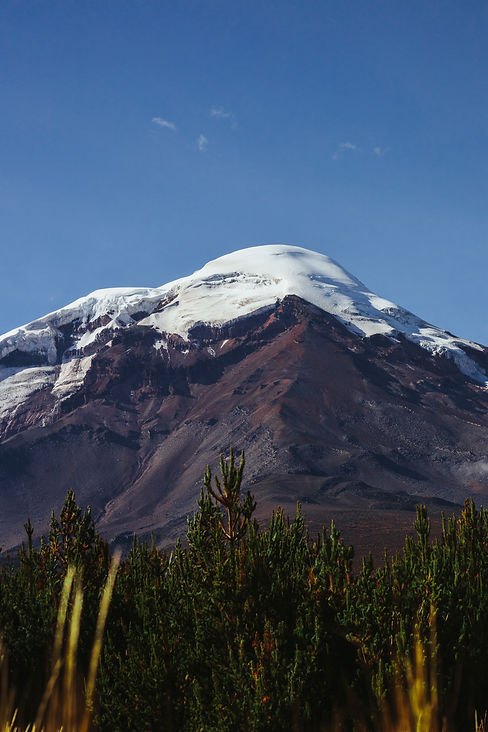
CHIMBORAZO
1.4667°S / 78.8°W
Four hours Southbound from Quito, down the route of volcanoes, lies the towering Chimborazo. Taita Chimborazo, as it is colloquially known, is not only the tallest mountain in the country, but also the closest point to the sun if measured from the center of the earth. Standing at an impressive 20,548’ (6263m), this mountain has not one but 3 main summits; Whymper, Veintimilla 20,429’ (6227m) and Politecnica 19,094’ (5820m). Physically and mentally demanding, this mountain is only for the bold.
This climb requires an excellent level of fitness, sufficient acclimatization for the high altitude, and previous glacier experience (using crampons, an ice axe, and traveling in a rope team).
We will start hiking from Hermanos Carrel Refuge 15,748’ (4800m) for about 4 hours until we reach High Camp at 17,552’ (5350m). Once here, we will rest in our tents. In the afternoon we will prepare and double check all of our gear, eat a light dinner and get as much sleep as possible.
There are multiple routes for varying skill levels. Most commonly we utilize the El Castillo Route on the North Face, but there is also The Original Route, and The Technical WI4 West Face. If you're feeling ready for a technically demanding adventure and have at least 10 high altitude peaks under your belt, look no further than the Integral de Chimborazo, which connects all 4 summits.
Starting the ascent well before midnight, the moonlight and a blanket of stars will accompany you. Our normal trajectory takes us up the El Castillo Route – starting over the ridgeline towards the saddle at 18044’ (5500m). Here we continue up 30-45 degree slopes navigating crevasses as you reach skyward. Reaching the summit near sunrise you may even catch a glimpse of this formidable giant's shadow on the surrounding sierra below and admire the most stunning views of other snow capped volcanoes in the Ecuadorian Andes. We will climb back to high camp, pack our belongings, and then walk the remaining distance to the parking area, where our transportation will be waiting to bring us back to Quito for a well deserved celebration.
Average Completion Time
12 - 14 hours
Elevation Gain
Parking lot to Camp one: 1640’
Camp one to Whymper Summit: 3297
Experience Required
Ice Climbing helpful, Glacier School
Gear Required
Standard Mountaineering gear*, 0 degree sleeping bag
ANTISANA
0.48453°S / 78.1423°W
While the least predictable of all the mountains on this list, due to its proximity to the Amazonia basin, Antisana is the most impressive mountain in the region, towering at 18,891’ (5758m). Antisana is also known for its solitude, as it is one of the least visited mountains on this list. This mountain is not for the faint of heart, but one for those wishing to test their mountaineering skills and mental fortitude. The route on this crowned mountain is ever changing due to the heavy snowpack caused by the convergence of currents where the Sierra meets the Amazon. This requires climbers to employ various climbing techniques, with the potential to utilize ice climbing skills.
Leaving Quito, we will enter the incredible Antisana Ecological Reserve, home to the Condor, the national bird of Ecuador. Passing the checkpoint of the reserve, we will set up camp at the foot of the mountain near 14,765’ (4500m), as there is no refuge on Antisana.
We will leave camp around midnight to start our ascent, reaching the glacier nearly an hour into the climb. From there, we will take a short break before navigating the numerous crevasses, ice bridges, and steep slopes in the ever shifting terrain of the mountain. On a clear day, Cayambe will be visible to the North, with Cotopaxi and the Ilinizas nearby to the South West. A personal favorite of our guides, this mountain never ceases to amaze even the most experienced mountaineers.
Average Completion Time
8 - 10 hours
Elevation Gain
3803’ (1159m)
Experience Required
Glacier School
Gear Required
Standard Mountaineering gear*


ILINIZA SUR
0.659°S / 78.714°W
Are you keen on honing your technical rock and ice skill? This may be the mountain for you. Accessed from the same trailhead as Ilinizas Norte, Ilinizas Sur, standing at 17,267' (5263m), is one of the most technical mountains in the country, ranked just after the 7 summits of El Altar towards the south. From the trailhead, this mountain is reached one of 2 primary ways – by the standard route over large crevasses and up the north-facing 2000 foot ice ramp, or the more technical mixed-alpine ridge Celso Zuquillo (WI2 M2-3 R). In order to climb this mountain, you must have prior knowledge and experience on mixed ice & rock climbing.
Only a 2 hour drive from Quito, we’ll arrive at the La Virgen parking lot at the base of the mountains. We’ll double check our gear, and load our bags on the mules for transport to the refuge. We’ll arrive at the refuge, around 15,416’ (4700m), after a moderate 2 hour hike. We will rest, enjoy the views, eat a prepared dinner, and spend the night in the refuge.
Starting our second day around 2am, we will enjoy a quick breakfast, and then begin our journey traveling through the lower scree and moraine for about 1.5 hours. As we prepare to ascend the ramp at the bottom of the glacier, we will rope up, and begin to utilize our ice climbing gear. Buckle up - the next portion of this route is a sustained 2000’ (610m) 50-60 degree snow and ice ramp. This will take us around three hours, putting us on the summit right as the first sun beams hit the horizon, creating some magical color shifts in the sky. After enjoying this moment, we will rappel down to the base of the ramp, walk back through the scree field, enjoy some tea and a small meal, pack our gear, and descend back to the parking lot. We will arrive in Quito later in the afternoon.
Average Completion Time
5 hours Standard Route, 6-8 hours Celso Zuquillo
Elevation Gain
Parking lot to Refuge Nuevo Horizontes- 2457’
Refuge to Summit- 1851’
Experience Required
Ice Climbing, Glacier School
Gear Required
Technical mountaineering gear including 2 technical Ice axes + Ice screws, carabiners. 15 degree sleeping bag
ACCLIMATIZING

RUCU PICHINCHA
0.1708° S, 78.6126° W
After stepping foot in Quito, it is nearly impossible to miss the jagged summit of Rucu Pichincha towering over the Ecuadorian capital city at 15,696’ (4784m). This climb is one of the most accessible hikes in the region and a great trek to prepare for higher-altitude attempts.
The trail begins at Cruz Loma, which sits atop of the Teleferico, South America’s highest gondola. Accessed by the gondola, the most popular route weaves up the side of the mountain through the sandy trails and rock. For experienced climbers, you can challenge yourself to the East Ridge climb, known as the Paso de la Muerte.
While hiking Rucu Pichincha on a clear day, you will be able to take in the sights of some of Ecuador’s most impressive volcanoes, including the famous Cotopaxi, just 34 miles (55km) from Quito.
Round trip from the top of the Teleferico to the Rucu summit takes most hikers about 4 hours. Our goal is to make it back to the Teleferico by mid-afternoon to avoid rush-hour city traffic.
Average Completion Time
4 - 5 hours
Elevation Gain from Trailhead
2724’ (831m)
Experience Required
None
Gear Required
Sun Hat, Puffy, Rain Coast, Day Pack, Water bottle, Trekking Poles. Harness, helmet, locking carabiner and gloves needed for Paso de La Muerte
ILINIZA NORTE
-0.6633° S, 78.7150° W
As you make your way south along the route of volcanoes, through the quaint town of Machachi, just south of Quito, lies the Illinizas Ecological Reserve. Here you will find two opposing sister peaks. Although these peaks are in close proximity, and share a refuge, the geographical location of the two allows one peak (Ilinizas Sur) to remain glaciated, while the other (Ilinizas Norte) is mostly rock covered - the perfect combination to prepare for Ecuador's big mountains.
Standing at 16,818’ (5126m), this mountain will surely get you stoked for your upcoming glaciated adventures. There are two main routes to its summit. The standard route, which runs up through patches of scree and includes some scrambling over the rocky terrain. If you're looking for a little more adventure, ascend on the Northern ridge where you will be confronted with 3x grade 5 rock pitches–a surefire way to get your adrenaline pumping.
Average Completion Time
4 - 5 hours
Elevation Gain from Trailhead
Parking lot to Refuge Nuevo Horizontes- 2,457’ (749m)
Refuge to Summit- 1,402’ (428m)
Experience Required
None
Gear Required
Sun Hat, Rain Coats, Day Pack, Water bottle, Trekking Poles, Helmet, Harness, Locking Carabiners, gloves, buff, and sunglasses with side protection.


PASOCHOA
0.4333° S, 78.4833° W
Pasochoa, standing at 13,780’ (4200m), is a beautiful & extinct volcano less than an hour outside of Quito. Its last eruption, some 100,000 years ago, left a wide open caldera that today is home to many species of flora and fauna, including the country's national bird: the Condor. We will hike to the mountain's peak through the tall golden grasses of the paramo and up towards its rocky summit, where we can observe the beautiful and scenic views of the Ecuadorian countryside.
This is an easy ascent, taking us between 2-3 hours to reach the summit. We will rest at the summit and enjoy a scenic lunch before hiking back down to the trailhead. We will be back in Quito in the afternoon so we can relax before our upcoming climbs. Pasochoa is a great way to start your journey traversing through the mountains of Ecuador.
Average Completion Time
4 - 5 hours
Elevation Gain from Trailhead
2600' (793m)
Experience Required
None
Gear Required
Sun Hat, puffy, Rain Coast, Day Pack, Water bottle, Trekking Poles
QUILOTOA
0.8583° S, 78.9034° W
The Emerald and Sapphire Gem of the Northern Andes, Quilotoa is a breathtaking crater lake found in the Illinizas Ecological Reserve. The view from its rim at 12,841’ (3914m) lends itself to sweeping views of never ending blue and green hills. Here you can take the most common mules route to the bottom of the crater where you can enjoy kayaking, a leisurely picnic, or, if you're up for it, circumvent the rim for a more challenging trek.
Average Completion Time
Lake Trail 30 minutes down, 1 hour 15 up
Rim Trail 5-7 hours RT
Experience Required
None
Gear Required
Sun Hat, Rain Coat, Day Pack, Water bottle, Trekking Poles


EL CORAZÓN
0.531° S / 78.659° W
El Corazón, standing at 15,718' (4791m), is located on the western side of the Avenue of Volcanoes, just south of Quito. Corazón is one of a few climbs used to acclimate for the larger volcanoes in Ecuador. Reaching the summit requires a fun, short class 3 scramble.
Directly translated to"heart", this volcano is named as such because some claim to see the shape of a heart from the northwest. The summit itself is directly on the crater rim, providing excellent views of Cotopaxi and Los Ilinizas nearby.
Average Completion Time
3 - 4 hours
Elevation Gain from Trailhead
3786' (1154m)
Experience Required
None
Gear Required
Sun Hat, puffy, Rain Coast, Day Pack, Water bottle, Trekking Poles
RUMIÑAHUI
Located within Cotopaxi National Park, Rumiñahui is as fun as it is beautiful. In Quichua, Rumiñahui means "stone face", and is named after the loyal general of the last Inca Emperor, Atahualpa.
Starting at 12,464' (3800m), we will gradually around the Limpiopungo Lake before making our way to a gentle ridge with some light scrambling.
Average Completion Time
6 - 7 Hours
Experience Required
None
Gear Required
Sun Hat, puffy, Rain Coast, Day Pack, Water bottle, Trekking Poles

FUYA FUYA - Photo Coming Soon!
It's an absolute pleasure to summit one of Ecuador’s most accessible volcanoes. Fuya Fuya, also known as Cerro Negro, stands at 13,986' (4263m). The ascent begins at Lake Mojanda and meanders through the tall paramo grasses, continuously revealing the fantastic views of the surrounding mountains and lakes. The trail eventually drops you off at the saddle between the East and West Summit, where we will continue to the East. The summit is guarded by a light rock scramble.
On a clear day, you will be able to see the peaks of Cayambe, Cotacachi, and the Imbabura crater, as well as the village of Otavalo, and Quito in the distance.
Average Completion Time
3 - 4 hours
Elevation Gain from Trailhead
2600' (793m)
Experience Required
None
Gear Required
Sun Hat, puffy, Rain Coast, Day Pack, Water bottle, Trekking Poles